The past several years have seen the construction industry embrace a breadth of technologies focused around the collection and distribution of data, minimizing delays in production. These solutions can give each team visibility into the newest data and details while in the field, meaning issues are caught before people and supplies are on site. Despite clear benefits, construction solutions have been adopted slowly, as they are typically expensive and require time and technical training to master.
Among these solutions are laser scanning sensors, which are gaining traction in the construction process as they become more accessible. As these scanners once cost $100k plus, and required hours/weeks of special training and desktop computer systems, they were unrealistic for most construction projects. However, new tablet based systems from companies like Lenovo, Asus, and nVidia, which have integrated the Google Tango 3D camera, allow access to these tools for a sub-$500 dollar price.
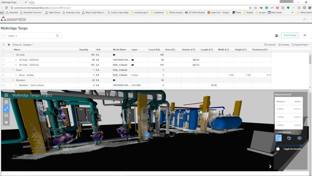
Using laser scanning technology on construction projects adds clear value in terms of time management and logistical planning. These sensors give teams the ability to quickly capture and compare between the intelligent 3D design model and the sensor data, a process that would have previously taken weeks. With field tablets, and software from companies like DotProduct, users can quickly check for clearance issues between two different systems, validate foundations for equipment, and check if pipe connection points are correct before these items are even brought to the job site. Additionally, having 3D design in the field allows you not only to see that there is a potential clash between the installed steel and the MEP system that is being installed tomorrow, but to query the actual system in question. You can then create an intelligent RFI that extracts the attribute values from the 3D models, and provides a way to reduce time and mistakes by mislabeling systems, or components while working in the field.
As more tech solutions are adopted to augment everyday constructions tasks, a common issue is finding a place that can host and easily share data contributed by multiple solutions. Assemble’s cloud based project management integration with 3D image and point cloud data allow collection and deviations between the actual and 3D design to be shared in just minutes. Moreover, Assemble offers one of the only federated data models for the construction industry that allows projects to support not just one specific type of authoring platform, but to combine and resolve the historical interoperability issues between different CAD modeling platforms. As we continue to expand the ability to store and manage sensor data on projects, we are researching ways to use these findings on future projects with post project trending and other analytics. This allows our clients to learn from past project performance to optimize construction in the future.
 This blog post is by Mark Klusza. Mark Klusza is the Chief Innovation Officer at Assemble Systems. With a career expanding over 30 years in the construction industry, Mark has started and successfully grown multiple software companies in the construction space specializing in 3D imaging, laser scanning and data management. Mark is a two-time ENR Top 25 Newsmakers for technological innovations. At Assemble, Mark is focused on driving continued innovation in the solution offering and expanding the company’s footprint to a wider audience in the AEC industry
If you enjoyed this post, please help it spread by emailing it to a friend, or sharing it on Twitter or LinkedIn.


Comments are closed.